(NEW YORK) — The first snow of the season struck the Midwest this weekend, and more snow is on the way for the North in the next few days while freeze warnings hit the South.
The snow forecast
Very heavy snow — at rates of 2 inches per hour — fell overnight in Valparaiso, Indiana, with more than 9 inches of snow reported as of early Monday.
South Bend, Indiana, has reported more than 8 inches of snow, while more than 1 foot of snow has fallen in some parts of Michigan and Wisconsin.
Chicagoans are waking up to 1 to 2 inches of snow, with another brief round of light snow expected Monday morning.
This lake effect snow event will continue along eastern and southern Lake Michigan through Monday afternoon. Some areas along the eastern side of Lake Michigan could get more than 6 inches of snow on Monday.
One to 2 inches of snow is possible in Indianapolis, and even Louisville, Kentucky, could get up to 1 inch of snow.
In the Smoky Mountains, places like Gatlinburg, Tennessee, could see up to 8 inches of snow, and higher elevations could get up to 15 inches of snow and strong wind gusts.
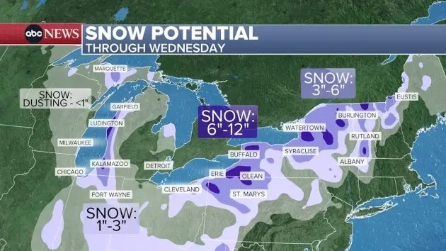
Further east, areas downwind of Lake Erie and Lake Ontario will see major lake effect snow on Monday night.
The deep freeze forecast
Parts of the South are waking up to their coldest weather of the season on Monday, with temperatures dropping below freezing in Texas, Oklahoma and Arkansas.
Dozens of daily record low temperatures are possible across the Southeast on Tuesday morning. The temperature is forecast to plunge to 28 degrees in Wilmington, North Carolina; 31 degrees in Savannah, Georgia; 30 degrees in Mobile, Alabama; and 26 degrees in Montgomery, Alabama. Even Miami is forecast to drop to 48 degrees.
Copyright © 2025, ABC Audio. All rights reserved.