(NEW YORK) — Tropical Storm Imelda won’t make landfall in the United States, but it will skirt close to the Southeast coast, bringing rain, strong winds, high surf, rip currents and isolated flash flooding or coastal flooding.
Here’s what you need to know:
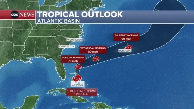
As Imelda moves north, the storm will bring rain to the Carolinas on Monday and then stretch from the Carolinas to Virginia by Tuesday.
Imelda is forecast to bring 1 to 2 inches of rain to the South Carolina/North Carolina border on Monday and Tuesday. The Myrtle Beach, South Carolina, and Wilmington, North Carolina, areas may see 2 to 4 inches.
Dangerous ocean conditions are also forecast from Florida to North Carolina. Rip currents are expected for much of the East Coast and high surf alerts are in place.
Georgia, South Carolina and North Carolina could see waves reaching 5 to 10 feet from Monday evening through Thursday morning. On Monday and Tuesday, waves could hit 11 feet in northern Florida and southern Georgia.
A wind advisory is also in place on Monday for the Central Florida coast. Winds could hit 40 mph in Melbourne, Palm Bay and Port St. Lucie.
Imelda will move north on Monday, and then when it’s positioned east of Central Florida on Tuesday morning, it’ll take a steep turn northeast and head toward Bermuda. Imelda may hit Bermuda as a hurricane on Thursday morning.
Meanwhile, Humberto, a Category 4 hurricane, will bring heavy rain to Bermuda on Tuesday. Humberto will then continue to move northeast out into the Atlantic.
Copyright © 2025, ABC Audio. All rights reserved.